
The Landscape of the Park around 1910
One of the most detailed descriptions of Chevy Chase Lake comes from James Pugh’s memoir. Mr. Pugh, who had a long career as a lawyer and public servant, was a retired circuit court judge in 1976 when he wrote his brief memoir about the amusement park. His family moved to Chevy Chase in 1906 when he was just three or four years old. When he was ten, he began to work at Chevy Chase Lake as a hat check boy. A typed copy of his 1976 memoir, signed by Mr. Pugh in 1988, can be read by clicking here: James Pugh's Memoir PDF.
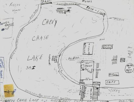
Mr. Pugh included a detailed sketch of the park with his memoir, and his hand-drawn map (see above) is our best source for understanding how different buildings and attractions were arranged at the park around 1910. In his map, he indicates the “fairy lights” in red, white and blue strung around the lake. He locates the Café, the Bowling Alleys, the Shooting Gallery, the Boat Swings, the Bandstand, the Dance Pavilion, and even the short-lived Pony Track, later the site of the Merry-Go-Round. Notice the gates at either end of the Dance Pavilion – admission to the amusement park was free, but to dance, you had to pay. And you would need to tip the hat check boy – perhaps Mr. Pugh, or one of his brothers!
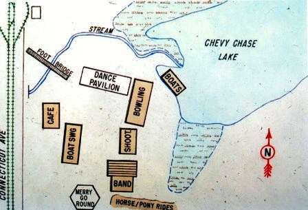
You can compare Mr. Pugh’s hand-drawn map from memory with a map drawn by William Duvall for a 1995 lecture at the Montgomery County Historical Society. Based on several old maps and surveys as well as Mr. Pugh's map, it reflects the shape of the lake and some of the existing structures in the 1930s. The octagon-shaped building is identified as the Merry-Go-Round, but it was labeled a Dance Hall in an engineering survey of 1937 prepared for the Chevy Chase Land Company (CCHS 1988.14.36). Perhaps the later dance hall was built at the same location or building footprint as the earlier Merry-Go-Round, which according to Mr. Pugh had replaced the Pony Ride Tracks in 1910. You can see the marshy areas where Coquelin Run and another small brook entered the lake – these must have been where James Pugh and his friends caught frogs.
Many of the features that Mr. Pugh described are echoed in the advertisements and publicity for the amusement park. However, the tragic drowning of the teenage couple was not in 1916, but 1912. There are two other details in Mr. Pugh’s account that we cannot confirm: we have found no record that John Philip Sousa performed at Chevy Chase Lake, though we know that his music was performed by a section of the U.S. Marine Band. And although Irene Castle and her husband Vernon played a big role in promoting the new dances of the teens, we have yet to find evidence that they actually danced at Chevy Chase Lake. And Mr. Pugh does not mention that people of color were not allowed to enter the amusement park -- unless they were musicians or performers.
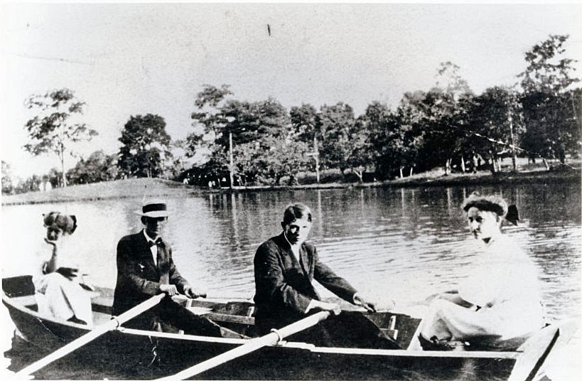
Mr. Pugh gave the photograph below to Mrs. Edith Claude Jarvis. If you look beyond the people in the boat, to the shore on the other side of the lake, you can see the strings of lights that went around the park.